Let me begin by saying that this was a bad idea. I had decided to climb a mountain and then hike to a survey beacon with no paths to it, alone, on a day with heavy fog. Everything turned out fine in the end, but if you’re reading this there are probably some lessons you can learn the easy way.
I started hiking at 5:58am when there was just enough light to make out the next 10 meters in front of me, and since there was a well defined trail, this part was relatively easy.

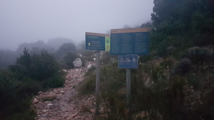
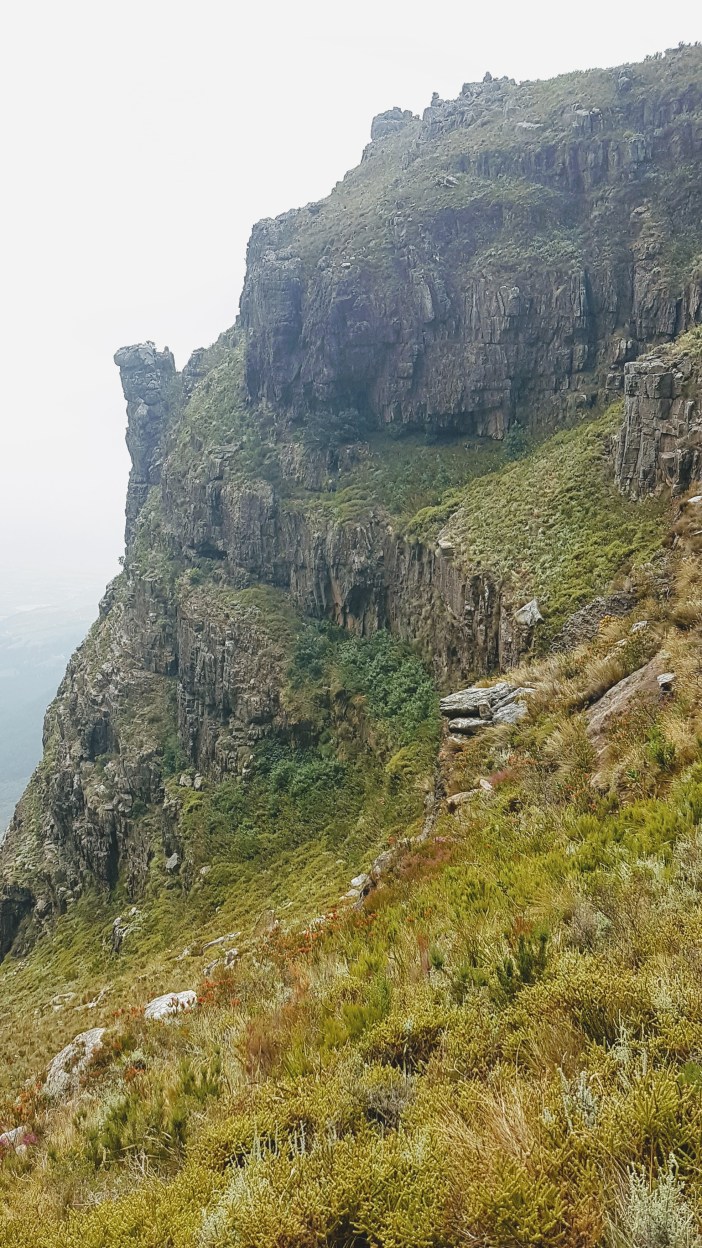
The Miaspoort Trail is not in great condition, there are sections that have been damaged badly by erosion and never repaired. Most of my photos from the first bit are moody fog photos. I generally don’t mind hiking in fog, but you’ll see later in this post why it can be a problem in certain circumstances.

The hike up is a rather brutal 1.5km with 500m elevation on not-the-best path, but I did it and got to the top in just under two hours. That’s the kind of pace I push uphill with plenty of stops to catch my breath look at the wonderful view, or fog.


At the “summit” of the Miaspoort trail you have two options:
Option One: turn right and curve around the back of the buttress and up to the Hugenot Peak and the Italian Cross, a gigantic steel cross which is a memorial to the Italian Prisoners of War who died while building the Hugenot Pass. This is an additional 377m elevation over 1.5km, so slightly easier than the half.
Option Two: turn left and take the road less traveled. There are no paths or routes here, I can’t emphasise this enough. Before setting off I had spent a fair amount of time on Google earth and other mapping platforms scouting the terrain. It looked relatively inviting. A flat plain that would be easily traversable. In reality it was a rough and undulating rocky hell. Thick bush, often at chest height and the necessity to be boulder hopping while unable to see where you were landing meant that every step could be the one where your foot disappeared into a hole. The mist made it difficult to see further than a few meters ahead, which made planning my routing even more tricky.

Mistake 1. Hiking an off-trail route by yourself is not smart. I had emergency contacts who knew where I was and where I was going and the specific route, and even live GPS tracking. I have no doubt that they would definitely have been able to find my body.
Mistake 2. Not planning my actual traverse beforehand and instead ended up just using the GPS bearing to head to the beacon. I’m lucky that I have a fair amount of orienteering experience, both from hiking courses and from sailing, but I had assumed that on the day I would be able to get to some higher ground and plan my traverse visually. The fog made everything impossible. I didn’t have any points of reference (ie. a huge peak in the distance to keep to my left etc).
Mistake 3. Not realising that a direct-to-the-beacon GPS route would take me over numerous cliffs. This one is a bit trickier to plan for beforehand because maps struggle to give you the context of what is impassable. I can’t jump down a 3m cliff, but on a map that cliff doesn’t even exist. What I should have known is that the direct route would take me very near the cliff faces and that terrain in general might be difficult to traverse. Schoolboy error.

So in the fog of war I trusted my trusty GPS and compass to head in a straight line to the beacon that was 1.5km away. This resulted clambering though thick bush, uphill, over rocks for a quite a long time, only to discover that I was at a cliff face that dropped spectacularly hundreds of meters down to the bottom of the mountain. Idiot. Thick fog meant that I still could not see where the cliff ended (or even the other side of it) so I just had to start traversing the top of the cliff to get “around” it. This meant climbing back downhill a lot, still bundu bashing through thick bush and sometimes climbing up or down small faces with a 15kg pack on my back.

Eventually I was at the neck (most inland point) of the cliff. Only 800m left to go in a straight line up to the survey beacon. A some point I had slipped on the wet-from-fog rocks and with my full weight, slammed my shin into a rock. This was bleeding and the bundu-bashing was now constantly scraping thorns over the wound. Uphill, climbing, jumping, slipping, drudging up and up, Half a league, half a league, Half a league onward into the foggy darkness. This was not really fun any more. Only 500m to go.


I found myself standing at the edge of another utterly spectacular cliff with fog being blasted up by the wind. I could not see the other side, but far in the distance, 400m away, when the mist cleared just enough, I could see what looked like a trig beacon… and a bottomless pit of fog between us. Normally in life I would have lost my composure at this point, but when you’re alone and your life really does depend on it, you tend to process things differently. I was utterly exhausted, but I knew what I had to do. Start heading back downhill, traverse the cliff and hopefully on the other side there’s a direct line to the summit.

It’s at this point that I realised another important lesson. It’s very easy to gauge distance while hiking if you can see everything for a few kilometers, but when you add fog things become terribly disorienting. Could there be another cliff between me and the summit if there is only 300m to the summit? How far have I walked now? Which direction did I even come from? Why does every cliff look the same? Without a GPS and/or compass I sincerely believe that even an experienced mountaineer could get themselves lost up here.

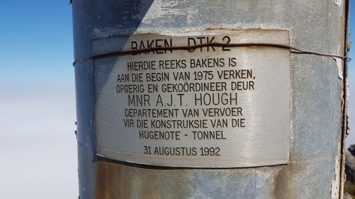
Finally through the mist I saw the outline of what must be the summit. I tempered my enthusiasm, keeping myself prepared for the likelihood of some additional drama that would force me off course again, but as I climbed the fog dispersed and it became more and more clear that the summit was indeed just a few more hundred meters uphill from me. And then eventually, the site that hikers love, the survey beacon. It had taken me an additional 2 hours to hike the 1.5km from the “summit” of the Miaspoort Trail to the survey beacon. It was meant to be “relatively flat”, 20 minutes maybe.


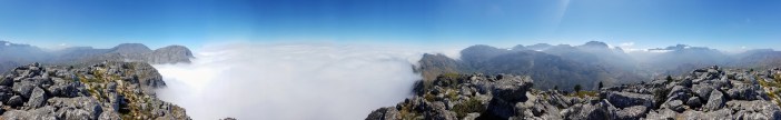
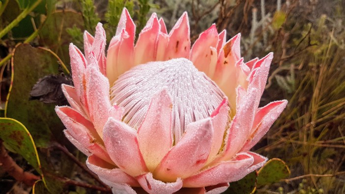
The view was obviously spectacular. I was on top of the world, and in one direction all I could see for hundreds of kilometres was the top of the most perfect field of white clouds. It was the kind of view reserved for Boeing pilots, but now I had it all to myself.
I took a few moments to collect my thoughts and congratulate myself on getting to the top, but the concern I had for the decent was already starting to weigh on me. I decided to set that aside momentarily and enjoy my time at the summit.
How to set up a portable radio station:
- Step 1. Get the 7m telescopic mast extended and resting on the ground.
- Step 2. Unravel the linked dipole antenna and affix it to the top of the mast.
- Step 3. Connect the coax cable to the antenna and tape it to the mast. If it’s windy, tape all the joints to help stop collapsing.
- Step 4. Lift the whole assembly up next to the survey beacon, wrap the beacon and mast with the orange straps and jam something soft in between the two to stop it the mast from getting scratched too badly.
- Step 5. Extend the dipole legs with cord on two winders, find a rock or tie it off to a tree. You want a 90 degree or more angle at the apex.
- Step 6. Get out the radio, connect up the power and start tuning around to see if you can hear something. Key the mic on CW at low power to check your SWR and make sure everything is working correctly.
- Step 7. Try and find a shady spot to sit in, this often means super uncomfortable, but slightly more protected.

Everything was working perfectly so I started seeing who I could reach out to. Within a few minutes I had made a bunch of contacts all across Southern Africa. It was almost too easy. I took out my “walky talky” (Hams call this an HT) and called out on 145.500 to see who was listening. Incredibly I was able to chat to people all over Cape Town, Paarl, Malmesbury, Stellenbosch, Durbanville etc. Height really helps, and the dense cloud cover didn’t seem to make much difference.

Based on the timestamps from my photos I had spent less than an hour playing with radios. This is quick and in hindsight it was incredibly wise. By 12:25 I had packed up and was heading back down. It had taken just over 4 hours to get to the summit, and normally decent would take 75% of that time. I would have hoped that my slightly more informed familiarity with the terrain would make it even faster since I wouldn’t go on any stupid detours, so maybe as quick as two hours if I was lucky. But another reality was starting to show itself; exhaustion. I was tired and sore and a little bit nervous. My legs weren’t as nimble as I would have liked them to be. It was trying to plan a better route back to the trail but much of my planning felt like it was resulting in even tougher hiking (at which point you start to doubt your cognitive agility).

I won’t give you the Charge of the Light Brigade version, but I will say that it was tough and there were some times where, even with better visibility and a “plan”, I still had to double back on myself. I lost my compass (a cheap one, but still) and relying on the GPS’s compass (which requires you to move in a straight line in order for it to calculate direction, when you’re clambering over rocks and bashing through bushes) is not easy. Eventually I found myself below the point that was the “summit” of the Miaspoort trail, I was exhausted, battered and bruised. I scrambled up still wondering if this was really the right set of rocks. That first sight of actual established, well worn path was a huge relief.

Without ever having experienced something like this you probably can not appreciate the cognitive load that one takes on when exploring without a trail. The trail is an auto-pilot. You just need to put one foot in front of the other… It is basically free energy. Take the trail away and you add the cognitive stress of planning and re-planning (which drains energy) AND the inefficiency of hiking through rough terrain (which drains energy) AND occasionally needing to double back, extending your total distance unnecessarily (which drains energy). The trail is a salvation experience. It is miraculous. I can imagine the ecstasy experienced by explorers thousands of years ago when finding a well worn trail.
The steep 500 meters of elevation descent was brutal because I was exhausted. My legs were jelly, the sun had decided to bake down and the wind was nowhere to be seen. I took a few steps, gathered my composure and gave my blisters a few moments of zen, and then took a few more steps. Repeat.
It was brutal at this pace, the longer you hang out in the sun the worse you’re doing. I found a small crook in the path partly covered by bushes. I had time and I wanted to rest so I pulled myself and my pack into the gap to enjoy the shade for a few minutes. A few minutes later a young couple come bounding down the path. They were moving so quickly that they almost didn’t see me. I said “Hello!” in as friendly a manner as possible so as not to startle them. They asked if I was okay, I said yup, just taking it easy, and then they bounded off.
I want to get myself fitter and stronger. I’ll probably never be quite as fast as the 24 year olds that sprint past me, but I believe that the body is capable of incredible transformations if you put the work in. I want these kinds of hikes to be doable without questioning my sanity. Ryan Sands just did 13 peaks, 100km and 6000m of elevation in less than 24 hours. At what point do we rise up against these mutants?

Near to the bottom of the Miaspoort trail is a small shaded river crossing. If you’ve been reading my blog you’ll know how I feel about rivers and embracing them at every occasion. I sat there for quite a while, pouring water over myself, enjoying the shade and soaking my battered feet in the water. I’ll spare you the detailed photos of my feet.
From the river it was just a short distance to the car. I still stopped to sit on a rock for a moment. It was now over 10 hours that I had been hiking, and starting to realise that I didn’t consume enough actual food. Another important lesson learnt. Force yourself to eat because by the time your body is exhausted you won’t really feel like eating.
The last bit was really just a zombie slog to the car. I had to walk along the highway for a short distance to get back to the car, and I’m sure passers-by must have thought I was a broken weirdo walking from city to city. I got to the car, shoved my pack into the back, started the engine to give the air conditioning a head start, then settled into a very weird drive home. Turned the music up loud and spent an hour feeling utterly great. Got home, showered, dressed my blisters and headed out to dinner with some friends. I think I was running on delirium by that stage.

Overall this hike was, in hindsight, fun. I see it now as a metric of my abilities. I want to be able to go back and do everything right, be stronger and fitter and get to the summit without hurting myself or doubting my sanity, and then get back down non-stop. So now the question is how do I get myself there?
Summary
Date: 16 February 2019
Distance and Elevation: 10.7km and 800m Elevation Gain.
Total Time: 10h14m
Coordinates: Parking spot Trail Head Trail Summit Survey Beacon
Conditions: Thick fog, very low visibility, very hot when the sun came out.
Radio Stuff: The survey beacon is well positioned for a mast. There’s not really anywhere to get any shade, so if you plan on staying for a while you should pack a tarp.
Notes: We grow from our mistakes.
