This summit had been on my list for a while as it is close to where we’re often based at the Breede River. This also marks only the second time in my life that I’ve been in the De Hoop Nature Reserve; the time before was when I was still in junior school!
We made our way to the river the day before, Graham on his motorbike, the wife and I with the hounds in the bakkie. The weather forecast was looking grim but I’ve learnt to never pay too much attention to forecasts. We arrived at around 4pm, Graham at 5pm. We played with some radios, braaied, prepped for the hike and then went to bed.

At around 3am the heavens opened. Lightning and thunder, torrential rain interspersed with gentle rain. It didn’t stop. By 6am we were up and it was still raining. There would be signs of the rain clearing and then, with the same ferocity as before, it would suddenly pour down again.

We waited, but had made peace with the fact that our hike was likely going to have to be postponed. Graham had to leave later that evening, so we couldn’t try again tomorrow. We made breakfast and watched the rain. It was lovely, but not as lovely as hiking.

At around 10am the sky started to clear, the rain quietened to a dull patter on the roof. We waited for it to return like it had so many times before… the lull seemed to be lasting, we decided to carpe diem and make a run for it, quickly getting our boots on and the bakkie packed. It’s about a 20 minute drive from the house to the De Hoop conservation centre, it drizzled occasionally on the way, but not enough to scare us off.

De Hoop had that chilly post-rain feel to it. Everything looked clean and cold, but inviting. We bought our permits and drove to the trail head. This hike isn’t particularly demanding but we knew that we were tackling it with a high likelihood of being thoroughly and miserably washed out. We started hiking. The route takes you through small forest and then out onto the exposed southern slopes of the Potberg mountain. We hiked some more.
It was windy. It began to drizzle, we wrapped our bags… it began to rain, we pushed on… I could hear the water sloshing in my boots, always a great sign. The winds became violent and reminded me of Roald Amundsen’s heroic Northwest Passage traversal, except I had cheese and ham sandwiches in my bag and could still see where we parked the car 🙂

After a bit more hiking the rain subsided, and then the wind died down. Graham wasn’t feeling great and since the first rule of hiking club is “leave the weak behind“, I left him lying on some bushes with a packet of energy sweets and jogged the last 1km uphill to the summit. (He is a very experienced outdoorsman and joined me at the summit a short while later).

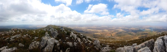
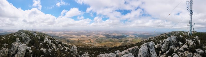
The summit, as most of them are, is quite spectacular. You get to see the river from a unique perspective, and see how it winds back on itself in places, a characteristic which is not obvious even when you’re on a boat travelling down the river.
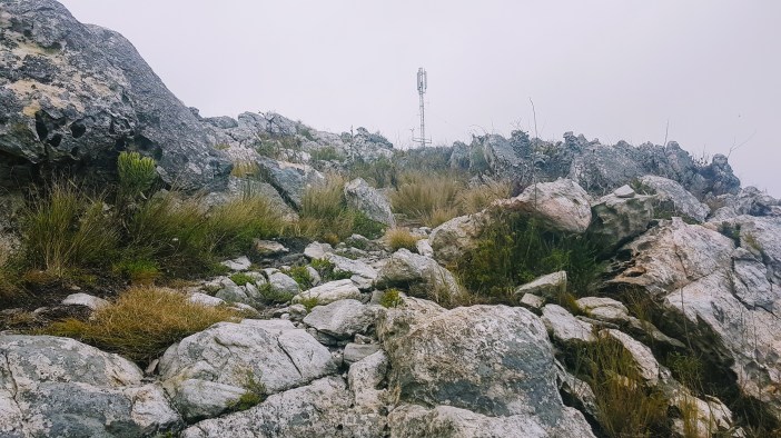
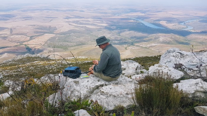
We set up the antenna and radio (a bit too close to the commercial repeater site, but we live and learn) and then started doing some radio’ing. The weather had made a full recovery by now and I was starting to get uncomfortably hot and worrying about sunburn, which always amazes me. My boots were still full of water.
Graham, the ever-avid birder, spotted a large white-ish bird flying nearby. It was massive and graceful. Then we spotted others, and as they flew closer it became clear that they were Cape Vultures, a bird that even I know is a big deal because of its endangered status. Tick.

The radio’ing was good but not great, mostly due to the local RF noise from the nearby repeater site. We did make the required number of contacts to “activate” the SOTA summit and I got to chat to the wife on the walky talky (she was a few km away directly beneath the summit)

Because my hiking buddy still had to ride his bike back to Cape Town we figured it best to pack up and head back. The walk back was less polar explorer and more afternoon ramble. De Hoop is a beautiful reserve and from the summits you get a good idea of how big and diverse it is. From dense forests to mountains, to beaches that go on forever. There’s a ton of hiking still to be done there and I look forward to heading back.
Summary
Date: 2 February 2019
Distance and Elevation: 7km and 420m Elevation Gain.
Coordinates: Start Potberg Conservation Centre (De Hoop) (take cash for a permit) Potberg Summit: -34.3712319, 20.563017
Conditions: It rained and then it got hot. Lovely!
Radio Stuff: There is a survey beacon but it currently has a microwave repeater strapped to it, so that won’t work. My suggestion is to get at least 100m away from the commercial repeater stuff, 200m would be better.
Notes: The second rule of hiking club is: No you can’t borrow my socks.
