Mont Rochelle had been on my list for a few weeks. A friend had suggested one of the lower peaks as a great spot for a radio setup, but since the actual summit (Dutoitskop) was a SOTA summit I decided to get to the top instead. Got to collect those sweet internet points.

Mont Rochelle is a private Nature Reserve and very well organised. I called them a few days before the hike to make sure that I could set off before their official opening time and they were very friendly with their “yes, of course!”.

I was the first car in the misty parking lot at 6am. You park your car far away enough from the road that it feels relatively safe even though there’s no one there to watch it that early.
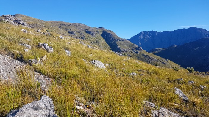
The routes are well marked and as I climbed the mist began to burn away and in its place were amazing views in every direction. There was no wind. I felt like I could have heard a caterpillar chewing a leaf nearby if I had listened carefully.
The more I hike the more I appreciate the quality of the trail. How well it was originally planned and how well it is maintained. The Mont Rochelle trails are wonderful in this regard.
It was a long slog for me, especially carrying a 15kg pack. I sent some friends an optimistic ETA for the top, then half an hour later had to “lol, no” that message. The last 2km felt like it was 90% vertical and someone had hid rocks in my pack. I slogged, stopping every few minutes to let my body cool down and my heart slow to a mild panic. My tongue felt like a flap of dry leather in my mouth.

I heard some people behind me on the trail, maybe as far as 1km back. They were gaining on me. The indignity of being passed by a group of hikers pushed me forward… This was my Rocky moment.

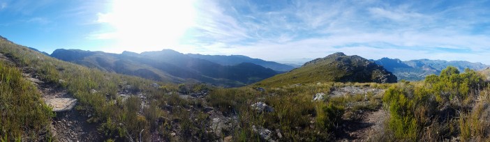
Eventually, as these things have a way of happening, I reached the top (first!). It was spectacular. The weather was absolutely perfect. Clear for a million miles in every direction with some high cloud cover to break the heat, and not a breath of wind.
Dutoitskop is a lovely summit as there are multiple ways up and it’s quite flat at the top, so that multiple groups can be up there chilling by themselves.
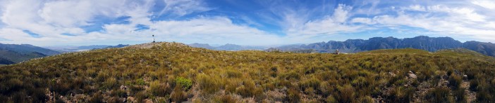
I obviously hogged the survey beacon because it makes putting up my antenna a lot easier. The radio’ing was fun, I “activated” the summit and then continued to chat to a few of the regulars from around the country. In some ways this is a bit like a group of friends who meet for coffee once a week. The same voices, with a few new ones every now and then. There was even a group of hams doing some operations at Piketberg (120km away) and I was able to chat to them crystal clear on my cheap Chinese walky talky.

This hike was way more about the beauty of nature (and the conquest of summits) than the radio. I spent a lot of time just looking. Dutoitskop is a very unique summit. From the top you can see Table Mountain and Lions head, the Teewaterskloof Dam and, incredibly, the Wind Turbines at Caledon. It is almost hard to comprehend all those things could be visible in the same picture.


The route down was tough. It was hot and my feet were burning from 20 years of not using them enough (and a bit of shitty genetics). The lack of wind persisted and the cool walk up was replaced by an oven walking down. Mercifully, the condition of the trail made it easier to descend while exhausted.


When I was a few hundred meters from the conservation office a young couple traipsed past me in their trail running shoes and hydration packs. I was okay with the indignity. I was still the first person at the top.
Summary
Date: 20 January 2019
Distance and Elevation: 8km and 750m Elevation Gain.
Coordinates: Start Mont Rochelle Nature Reserve (take cash for a permit) Dutoitskop: -33.8825236, 19.1491087
Conditions: I could not have asked for better weather on this hike. I imagine it could get blisteringly hot up there, so take lots of water. There are no streams on the Dutoitskop summit trail.
Radio Stuff: Highly recommend using the survey beacon for your mast, but beware that hikers will be walking past your kit, so take something bright to mark your lines.
Notes: This is a great hike and area in general. There are a bunch of shorter/easier options, so go have fun!
