Botterlary is one of those “mountains” that is used extensively as a commercial RF high-site. It was my first time up here and because I’m a huge nerd it was interesting to see how it was all laid out, but predictably it is not a great location for sensitive radio experimentation.

I met up with a few friends at Koopmanskloof Winery (who had kindly given us permission for the day). We drove Brian’s Landy a few hundred meters up the hill until we reached a boom across the road and parked out of the way. We then trekked the rest of the 2km up to the top of the hill. You should eat breakfast before you do these kinds of things. I of course hadn’t eaten breakfast and felt like dying a few times on the way up. It’s an unforgiving slog.

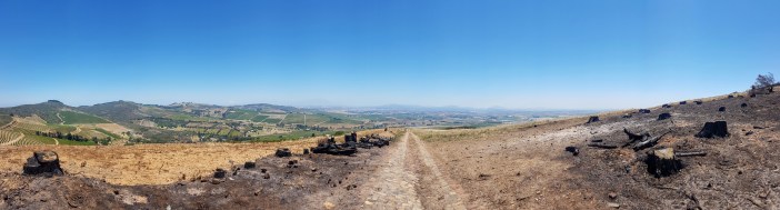
It is however still a pretty walk, and once you reach the top you’re surrounded by antennas and small buildings humming away ominously.
We set up in the shade of one of the small buildings and I did actually manage to make contact with one person who was only a few km away. There was an S9+ noise floor, which for non-radio people basically means so much interference that any signal that wasn’t absolutely booming in would not be heard over the noise.

I made the executive decision that we should move downhill, away from the towers and set up again to see how thing fared a short distance away.

The new location was much better noise wise; down to S3 and we immediately started making contacts with people all over the country. The surroundings were a bit spartan though, and a recent fire had made it even more so. My lack of breakfast continued to diminish my enthusiasm and we packed up as soon as we’d made enough contacts to consider the SOTA summit activated.
Overall a fun outing, but there’s definitely other hikes to do before this one.
Summary
Date: 16 December 2018
Distance and Elevation: 4km and 230m Elevation Gain.
Coordinates: Parking spot Koopmanskloof Winery (get permission!) Setup Spot: -33.9079654, 18.7720508
Conditions: Quite hot on the day, very little wind. Take lots of water.
Radio Stuff: Obviously the actual summit is noisy. There are some tall bluegum trees on the way up that would be great for an end-fed or possibly even stringing up a dipole.
Route: KML File
Notes: Your mom was right, breakfast is important.
