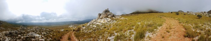
This is one of those truly magic hikes that inspire you to keep exploring because you never know what’s just around the corner.

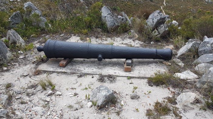
I am fascinated by this part of the mountain. There is a train line that most people don’t know exists, you can touch wagon wheel tracks carved into the rocks hundreds of years ago by the voortrekkers, there’s a canon that was used to notify people when someone had made it to the top, and last but not least, there’s a creepy old train tunnel that runs directly under the N2 at the top of Sir Lowry’s pass for the train you didn’t know about.

If I had another lifetime I would spend it documenting the incredibly fascinating micro-history of South Africa. The past of seeming insignificance gives history its texture. Knowing these little stories lets you find wonder in the smallest things. A groove cut into a rock can represent the beginning of an epic journey, a new life in a far away land.

Quick history lesson courtesy of Wikipedia
Gantouw in the Khoi language means eland and historically these large animals crossed the Hottentots Holland mountains at this narrow and steep pass. The Khoi and San people followed the eland and, after European settlement at the Cape, the pass became an important gateway to the Overberg for transport wagons hauled by teams of 24 oxen.
The earliest recorded crossing of the pass was by a Dutch East India Company surveyor, Hendrik Lacus in 1662. By 1821 more than 4 500 wagons were using the Gantouw Pass (Hottentots-Hollands Kloof) each year.
Starting in 1828, a new pass was constructed on the current route that would allow ox wagons to navigate the pass without difficulty. Construction began at a site about 2 km to the south of the Hottentots Holland Kloof, by the engineer Charles Michell using convict labour. The new pass was opened on 6 July 1830, and named after Lowry Cole, the Governor of the Cape Colony at the time.
In 1903 the route was upgraded again when a privately owned railway company built a railway line alongside the road with a level crossing (ie. train/car intersection) right at the top. This is another fascinating part of South African history. The rail industry was a bit like the current private space industry. A few mega wealthy individuals spending fortunes prospecting on which routes, technology and methodology would succeed. That’s a story for another time, but the battles left some interesting remnants, including a “train to nowhere” that I’ll write about another time.

Lets get back to the hike. Drive to the top of Sir Lowry’s pass and hook a right into the lookout point. Don’t leave valuables in your car. Take your bags and hop over the N2 to a small awkward section of tarred road that goes nowhere. The tar quickly becomes gravel and you’ll reach a fork.
Side Mission: The right (southern) route takes you down the hill and then runs parallel to the train track. When you’ve walked about 700m you’ll find a small path that leads to railway line. If you follow the railway line back towards the summit (600m) you’ll reach the southern entrance to the tunnel. The tunnel is roughly 250m long and the train line is still used! albeit very infrequently – Don’t be an idiot.

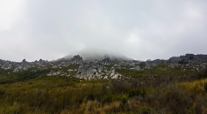
At the fork, take the left (northern) option. It’s a great walk that’s relatively flat and can be quite magical in the early hours of the morning. Around 1.7km in you’ll reach a small path to your left. From here you can see into the small valley that is the top of the Gantouw Pass. We’ll take this left route up for now as it gives us some altitude. I didn’t climb all the way up as I wanted a slightly more sheltered spot to set up in. I walked uphill about 350m and found my spot, but at this point you should really explore. It’s all quite spectacular.
I spent a few hours playing radio and exploring, then when I was done I headed back down to the original path and continued on a few hundred meters to the signage. Turning left (north-west) takes you into the Gantouw Pass. You only need to walk a few hundred meters before you start to notice the grooves cut into the rocks from the ox wagons. I encourage you to keep walking down the pass. The further you go the more you’ll appreciate the magnitude of getting ox wagons up that mountain.


Finally on my way back I hopped up the hill to the old signal canons. These canons were used for a few different things, but usually to announce that someone (often a trader) was coming. I’m guessing these were only ever fired at certain times of day so that people (in Strand etc) would know when to look up.


Once you start exploring these mountains you’ll realise that there are so many nooks and crannies to investigate. Starting from the same parking spot you could also embark on the 22km hike (with >1000m elevation gain) up to Hansekop, or go and look at this big hole (probably trespassing). The Hottentots Holland mountain range is massive and full of adventure. This little hike was the first hit that left me wanting more.

Summary
Date: 2 December 2018
Distance and Elevation: <6km and 150m Elevation Gain.
Coordinates: Parking spot -34.149124, 18.927797 Setup Spot: -34.140277, 18.939589 Wagon Wheel Tracks: -34.139108, 18.9379902 Cannons: -34.1394482,18.9376912
Conditions: Cool, overcast with a little bit of drizzle.
Radio Stuff: You’ll need a self supporting mast as there are pretty much no tall trees. The summit would provide a better take-off angle if weather permits. Had great contacts all over the country.
Notes: Leaving my car at the parking lot in the early hours of the morning was sketchy as frig. I wonder whether you could get an Uber from Gordon’s bay?
KML: Downloadable here.

Thank you for a well documented article. I intend taking my grandson on this trail. Will give you feedback.
Gantouw Pass – The Old Wagon trail
A guide to hiking approach routes
What’s in a name? Well there are three to choose from.
The Khoi people called the path T’kanna Ouwe or Gantouw, ‘Gan’ being the Khoi word for eland and ‘touw’ the Khoi word for path. Later travellers also took up this meaning, calling it the Elandspat (path of the eland). Later still – ox wagon travellers called it the ‘Hottentots Holland Kloof.Giving due respect to the indigenous people, I have adopted the Khoi vernacular; all be it the English translation, the Gantouw Pass.
The history of the pass, the ox wagons themselves and the story of the late 18th century Dutch porcelain shard that we found near the top of the pass are covered in my other three articles on the subject. Here I describe the possible routes that hikers take to visit this historical.
Common sense precaution:
• All of these hikes entail crossing railway tracks. This line is still in use so take care.
• Security has to be considered. No hiking groups have ever had an issue in this area, but hike in groups and minimise valuables you carry.
• Always let someone know where you are going and leave a contact number.
• Please respect ‘Private Property’ signs.
1/ From the N2 car park. A grade 1.5 hike. Duration 2 hours – on good tracks and paths.
From the Somerset West side of the N2, you will ascend to the top of the pass and then follow the sweeping bend as it swings left down the hill. One hundred meters down from the summit you will see a lay-by on the left. This is opposite the entrance to the Steenbrass dam road on the right. Traffic speeds round this bend, so take care.
Step out onto the old tarmac road and almost immediately look for a path on your left which heads up and diagonally right across the hillside. Cross the rail track to pick up the trail on the other side. As the path climbs a little more steeply diagonally right you gain the old tarmac road. Follow this right for 20 meters to reach a left leading path which again leads you up the hillside to reach the upper jeep track.
Turn right and follow this for a kilometre until you reach a sign pointing left to a footpath that ascends easily up for 200 meters to gain the crest of the Gantouw Pass. Look for the short trail on your left which takes you up to the signal cannons.
The Helderberg Renaissance Foundation is trying to restore to firing condition. The Foundation plans to conduct this event on National Heritage day 24th September each year.
Return the way you came, though if you know the paths you can strike out for a little way along the old Boland trail before heading down slope to pick up the old tarmac road again back to the cars. There and back, plus a stop at the two cannons should take no more than two hours.
2/ From the Old Knorhoek Manor. A grade 2.5 hike. Duration 4 ½ hours on good tracks and paths.
Please phone ahead – 082 771 5395 to say you would like to come to use their car park and if you would like to stop off on your return for refreshments.
The Knorhoek farm was granted to David Malan in 1717. It was transferred to his son Jacques Malan in 1790. The Manor House was built in 1795 and is a designated National Monument.
The Manor operates as a centre for weddings, board meetings, conferences and private functions. It is also a very pleasant refreshment stop at the completion of your hike.
Directions:
From Somerset West take the old Sir Lowry’s Pass road. Do not turn right across the rail line but carry on bearing left for a further 100m to reach the left turn to Knorehoek. After a kilometre along a paved road you will reach the Knorehoek security gate. Let them know you are visiting the Old Manor, which you will find on your right just 100 meters along from the security gate. Park in the field below the Manor House. Not in the Manor car park, which has limited space.
Pass by the main house front entrance and cross the back red brick paved driveway onto the track beyond. Shortly you will reach another farm track which you follow to your right. Take this track for some 250m diagonally right to meet a T junction. Now turn left and follow the track that passes alongside the boundary fence, uphill over the railway line to a junction. Your direction is now right, to follow the railway service road for a kilometre until you pass by the top of the Tre Donne estate. Carry on for some 100meters before turning left to follow a rough sandy jeep track that crosses open ground as it winds its way uphill for 1 ½ kilometres before reaching the rail line once more. Cross this and look for the easiest way to ascend the bank on the other side. Easier some 20m to the left. You will now gain and follow another jeep track right for 1 ½ kilometres to its end at a small quarry.
Hard to see, but at the quarry pick your way right and you will pick up a good path that climbs up above the rail line and which contours its way round the hillside, until the ground opens up and you find yourself close to the rail line once more.
Due to plantations and forestation it is all but impossible to follow the original lower line of the wagon trail, but now the continuation is clearly visible on your left.
You will enter the gully of the old pass, which at one time was much deeper, having been filled in by erosion over time. The way now is obvious as you walk uphill in the footsteps of the Khoi people and then those of the farmers and travellers. Wonder at the struggle and determination of all those who went before, as they cajoled their oxen up the ever-steepening pass, only to see many wagons crash down the slope.
As you climb up the pass look out for the Bawboom trees that sporadically grow either side of the pass. Your ascent will also bring you to more and more grooves in the rock caused by the ox wagons locked wheels as they ‘skidded’ downhill.
Once at the crest, look out for a rough 50-meter path on your right that will lead you up and round to the cannons.
3/ From Idiom restaurant.
Provided Idiom can supply you with transport to the quarry above the rail line, the hike will become Grade 2. Duration 3 hours starting and finishing at the quarry. Arrangements can be made to walk down the far side to the N2 lay-by, and be collected to be taken back to Idiom. This will lessen the duration, and you will need to follow the way as described in hike one – to the N2 car park, or be guided.
Follow directions as per Knorhoek Manor, but pass by the Manor to follow signs to Idiom, which is two kilometres further along the tarred road.
Spectacularly situated on the hillside far up the flank of the Hottentot Holland mountains, the restaurant offers beautiful views, fine dining and a selection of its own fine wines made from the vineyards you see spread out before you.
Call Idiom on 021 858 1088 to book ahead to see if arrangements can be made. A pleasant hike / meal combo is to arrive for breakfast, be taken to the quarry to begin the hike. Once back at the quarry, be collected, and then complete the day with an Idiom lunch and fine wine.
Steve Chadwick
March 2021